Text

Mining the Dispatch
This project explores and analyzes the topics that dominated the local news in Richmond during the Civil War. It uses a text mining technique called topic modeling to uncover changing patterns in the city's social and political history.
Proceedings of the Virginia Secession Convention
Secession: Virginia and the Crisis of Union is a collaboration between the University of Richmond's Boatwright Library, the Digital Scholarship Lab, Web Services, and University Communications. The project allows users to explore the context and full text of the spring 1861 proceedings where Virginians debated whether to secede from or remain in the Union.

Daily Dispatch
Search and explore the entirety of Richmond's newspaper of record during the Civil War.

TextMapping
TextMapping allows you to explore points of contrast and comparison between North and South, Democrats and Republicans, secessionists and unionists during the Civil War through visualizations drawn from five Civil War-era newspapers from two towns in Pennsylvania and Virginia.
Maps
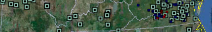
Visualizing Emancipation
Visualizing Emancipation is an ongoing project that details when, where, and how emancipation occurred during the American Civil War. It is funded by a Digital Start-Up grant from the National Endowment for the Humanities.

Marriage, Migration, and Emancipation
These maps accompany "Scales Intimate and Sprawling," an essay published in Southern Spaces, showing the migration patterns of black Virginians who formalized their marriages immediately after the U.S. Civil War. Marriage and migration were intimately related processes for those who rebuilt families in the wake of the interstate slave trade.

Mapping Richmond's Slave Market
In 1853, the painter Eyre Crowe visited Richmond and sketched its slave market. This project, a collaboration between art historian Maurie McInnis, the Digital Scholarship Lab, and the Valentine Richmond History Center, allows the twenty-first-century public a view of the Richmond Crowe saw. (Google Earth plugin required)

Voting America: Civil War Elections
An animated map of the presidential election of 1860 shows the spatial patterns of the fractured national political system that contributed to the Civil War. A similar map of the 1864 presidential election shows support for and opposition to Lincoln and the war.

Scale and Freedom
These maps were built to accompany Edward L. Ayers and Scott Nesbit, "Seeing Emancipation: Scale and Freedom in the American South," Journal of the Civil War Era 1.1 (March 2011). They show a few of ways in which wartime emancipation was a patterned, scale-dependent process.