The Fall of Confederate Richmond
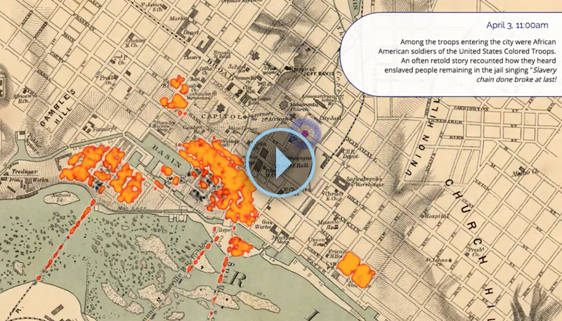
We know when and where many of the events of April 2, 3, and 4 occurred. Given their importance, some participants and observers recorded to the minute exactly when certain events happened. But for others we have ambiguous or even contradictory evidence. For instance, we know that looting was widespread on the night of April 3, but we don't know exactly when and where most individual acts of looting happened. (It probably is wishful thinking to hope that drunken looters would have kept detailed and accurate diaries.) To create this animated map we have considred a substantial number of sources and used our best judgment as to where to exactly to place events in time and space.
Indispensable newspaper accounts of the evacuation, fire, occupation, and Lincoln's visit appeared in the Richmond Whig, New York Herald, and New York Times in April 1865. Many of the key articles have been compiled by Mike Gorman on his Civil War Richmond website. The work of journalist Charles Coffin presents what little we know of slave trader Robert Lumpkin's efforts to evacuate his human property: his "Late Scenes in Richmond" in the June 1865 issue of the Atlantic and his Freedom Triumphant.
The video draws heavily from the research of others. Nelson Lankford's Richmond Burning: The Last Days of the Confederate Capital is arguably the best history of the fall of Richmond. For our map, A.A. and Mary Hoehling's The Last Days of the Confederacy and The Day Richmond Died were particularly useful as they provide nearly hour-by-hour accounts of events. For Lincoln's visit we relied on the detailed account provided in Mike Gorman's "A Conquerer or a Peacemaker?: Abraham Lincoln in Richmond" that appeared in volume 123.1 of the Virginia Magazine of History and Biography. Leon F. Litwack narrates some of the dramatic events related to the end of slavery in Richmond in Been in the Storm So Long: The Aftermath of Slavery.A number of other works were helpful as well: Rembert W. Patrick's The Fall of Richmond, Ernest B. Furgurson's Ashes of Glory: Richmond at War, and James C. Clark's The Last Train South: The Flight of the Confederate Government.
The map was created using the mapping library Leaflet, and many of the animated features use CartoDB's visualization tools.
This video was created for the April 4, 2015 "Richmond's Journey in Nine Questions" "Pop-up" Museum on Capitol Square.
The map was created by the Digital Scholarship Lab. Robert K. Nelson created and developed the code for the map. Justin Madron created and managed much of the spatial data. Nate Ayers created the framework for the website and assisted with the design of the map. Lily Calaycay georeferenced a number of events.