The union military's most prolonged contact with black southerners came near the water.
Note: Visualizing Emancipation is shelved for now, while we work on a new version.
Visualizing Emancipation
Visualizing Emancipation is a map of slavery’s end during the American Civil War. It finds patterns in the collapse of southern slavery, mapping the interactions between federal policies, armies in the field, and the actions of enslaved men and women on countless farms and city blocks. It encourages scholars, students, and the public to examine the wartime end of slavery in place, allowing a rigorously geographic perspective on emancipation in the United States.
About
Visualizing Emancipation organizes documentary evidence about when, where, and how slavery fell apart during the American Civil War. Funded by a We the People grant from the National Endowment for the Humanities, it shows how emancipation occurred unevenly across the South, beginning before the first major battles and ending after the end of the Confederacy. It shows the complex interactions between federal policies, armies in the field, and the actions of enslaved men and women on countless farms and city blocks.
Visualizing Emancipation maps a messy story, in which patterns partially visible today remained hidden to many involved. It presents a history of emancipation where brutality is sometimes easier to see than generosity and where the costs of war and freedom fell disproportionately on the most vulnerable in the South. The war that brought freedom to millions brought unmatched destruction and disruption. If emancipation was a process, it must have seemed a chaotic, directionless one to many caught up in it. Visualizing Emancipation shows a war in which alliances between enslaved people and union soldiers were uneasy and often tested, but which yielded, somehow, the end of slavery.
We have gathered in this map only a small slice of the available evidence documenting the end of slavery. We invite the public to help give shape to our understanding of emancipation by sharing events documented in archives across the country and online.
Introduction
"Visualizing Emancipation" is the first map of the most dramatic social transformation in American history, the emancipation of four million slaves in the Civil War. It brings together three kinds of evidence; where slavery protected by the US government and where it was not during the Civil War; where and when U.S. troops campaigned during that war; and where "emancipation events,"--documented instances where the lives of enslaved men and women were changing, sometimes for good, others for ill--occurred. By exposing the evidence on which it draws, "Visualizing Emancipation" allows students and the public to approach the sources to ask their own questions about emancipation and find out how their own locales and ancestors might have experienced the end of slavery. It allows scholars to ask new questions about where and when enslaved men and women escaped bondage, and what their lives may have looked like when they did so.
Like other maps, "Visualizing Emancipation" is both a tool for interpretation and an image that makes its own point. The end of slavery did not come about in an instant, with the Emancipation Proclamation. It began before shooting started and ended long after the last Confederate armies surrendered. It followed, in W.E.B. DuBois' words, as a "dark human cloud" at the rear of the Union's swift-marching columns. It could be found in the escape of fugitives, in Union and Confederate armies' conscription of enslaved men to work on fortifications, and in escaped slaves' offers to guide U.S. troops through southern wilds.1
Opportunities for freedom could at times seem randomly distributed, as men and women participated in mass exodus on some plantations while others nearby were left enslaved. Yet emancipation proceeded in patterns, not as a chaotic, secular rapture, in which men and women became free without discernible sequence, rationale, or order. Enslaved people, legislators, and armies, in fits and starts, imprinted the end of slavery on the American South.
Patterns
Enslaved men and women found release from their bonds in waves, rising and falling with the campaign seasons, the fortunes of Union arms and the pitiful defenses of contraband camps. Unlike the legal extension of freedom, which gathered momentum through acts, proclamations, and amendments, enslaved men and women did not experience emancipation as a process building on past success, pointing toward a future without bondage. As often as liberation was welcomed with exhilaration, men, women, and children also experienced war and freedom as dangerous flight and backbreaking labor, marked often by hunger, violence, and distrust of the liberating army.
Enslaved men and women were more likely to find freedom in some places than others. Freedom and Union arms pushed into the Confederacy by water and rail. Enslaved men and women living along the Atlantic seaboard-the coast and Sea Islands of South Carolina, within a day's walk of the North Carolina coast, and along Virginia's Chesapeake Bay-had the greatest and earliest opportunities to find freedom. Enslaved men and women living along the South's major rivers had a greater chance, too, especially those on the plantations of the Mississippi delta, along the Tennessee River in northern Alabama, and along Virginia tidewater's Potomac, Rappahannock, and James Rivers.
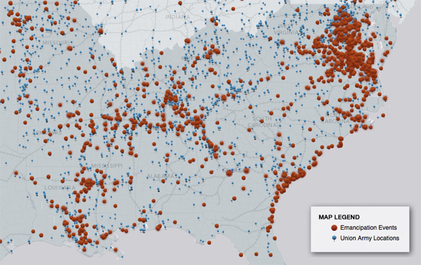
Those living or working along the South's 10,000 miles of railroads were also more likely to find freedom. Confederate civilians along the line between Corinth, Mississippi and Decatur, Alabama complained to their government at the close of 1862 that in the past year their enslaved workers "had been carried off in very large numbers, declared free, and refused the liberty of returning to their owners." Union officers had "pressed all the negroes in this country" around the Nashville-Decatur line by the end of 1863. Before he followed the rails through Georgia, Gen. William T. Sherman moved his troops along the Jackson-Meridian line in Mississippi with a train of refugee families extending as far as the column itself, or in Sherman's turn of phrase, "10 miles of negroes." Some ran to U.S. lines of their own accord, others were dragged without their assent. Once under Union protection, men and women found themselves in a legal state of freedom, yet with immediate constraints no less coercive than those they experienced under slavery, as they were put immediately to work cooking, digging, farming, or marching to war.2
Emancipation consisted of much more than the rush of enslaved people to Union lines. "Visualizing Emancipation" breaks the actions and experiences of enslaved men and women into what we have called emancipation event types, each carrying a pattern distinct from but related to the others. We were particularly interested in the experiences that marked the end of slavery. Both armies conscripted men and women into service, pulling them away from their homes and the forms of slavery they had known before. People of color took part in irregular fighting, raiding plantations while not enlisted in any military unit. They passed intelligence to the United States army and served as guides to troops. African Americans also suffered abuse, were rushed away from oncoming Union soldiers so that their owners might protect their human property, and were at times re-enslaved once they had escaped slaveowners' control.
Security
The patterns made by a few of these kinds of events suggest how emancipation begins to look differently once mapped in time and space, and broken apart by the different experiences black southerners encountered. Our research into the Official Records of the War of the Rebellion shows that African Americans were victims of war-related abuse more frequently once black men began fighting for the United States. Accounts of the abuse of men enlisted in the U.S. Colored Troops, including the atrocities at Fort Pillow are well-known. Attacks against non-uniformed black southerners also rose after 1862.
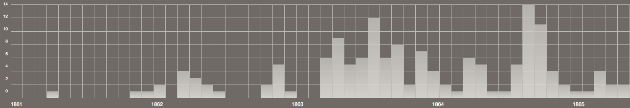
African Americans encountered more war-related violence after 1862. This timeline shows all events from the Official Records tagged as "abuse."
Occasionally this abuse came at the hands of undisciplined U.S. soldiers, such as those commanded by William Dwight who raped the enslaved women they found at New Iberia, Louisiana four months after the Emancipation Proclamation went into effect. More often abuse came at the hands of Confederates, who killed unarmed men and women at Goodrich's Landing, Mississippi, on Hutchinson's Island, South Carolina, at Helena, Arkansas and a large number of other places dispersed throughout the South. Irregular violence against African Americans composed a greater part of the conflict in the west than the east. Attacking black men and women was a regular part of bushwackers' to control Missouri, and violence against women and children who worked U.S. owned plantations along the Mississippi were at constant risk of attack by small, marauding units of Confederates.3
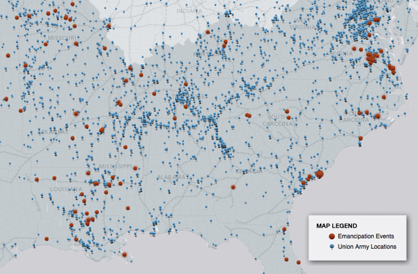
African Americans suffered war-related violence throughout the South during emancipation, but disproportionately in the West. The map above shows irregular violence against people of color during the war.
Freedom was more secure in the eastern theater of war, particularly in Virginia and North Carolina, than those in the West, but more dangerous to achieve. In Virginia, escaping slavery was a dangerous proposition because of the highly mobile, and numerous Confederate units operating throughout the state. The likelihood that an enslaved man or woman would be caught while attempting to get to Union lines was great, even if they were accompanying a U.S. unit. Confederate troops were eager to attack smaller commands that had moved in advance of the main body of U.S. troops. They captured hundreds of escaped slaves after halting Brig. Gens. James Wilson's and August Kautz's raid along the Danville Railroad in June 1864.4
Yet once behind Union lines in a refugee camp, fugitives from slavery were relatively safe. Few raiding parties penetrated Union lines to seize black southerners living around Fortress Monroe in Virginia or to New Bern, North Carolina. The tens of thousands of African Americans who left their farms in the tidewater regions of Virginia and North Carolina were secure in their freedom after the Emancipation Proclamation. Refugee camps and U.S. owned plantations along the Mississippi river did not share the natural geographic advantages of the Atlantic seaboard. These farms and villages were often lightly guarded and suffered frequent raids, some of which re-enslaved hundreds of men and women.
Scale
The events we gathered, detailing where and when men and women became free should be viewed together at multiple scales. From the widest vantage-point, we can discover differences at the level of the region, distinguishing between the likely experience of men and women in the East from those in the West. Examinations of differences at the local level require different vantage points and data with greater specificity. Each emancipation event is encoded with a geographic precision level, which appears as a halo around events. We surround events about which we lack great geographic precision with large halos, warning against misinterpretation. Events about whose location we have very specific knowledge do not receive these marks, and can be used for detailed, local-level analysis.
For example, it is clear that, from the widest vantage point, enslaved men and women ran away in greater numbers when United States army units came near. In many cases, this was because these units visited southern farms and either invited or forced enslaved men and women to leave with them. Our research suggests more complicated dynamics at work as well. When U.S. units led by Maj. Gen. David Hunter entered Augusta County, Virginia, in June 1864, they created new opportunities for enslaved men and women there. Twenty enslaved men and women working at the Central Asylum in Staunton left with the Union troops. Confederates stationed nearby reported the next day that the "Yankees" were "capturing negroes," and were intent on burning the railroad bridge at the cusp of the Blue Ridge mountains.5
Not all those who left their owners, however, went with Hunter's troops. Some took advantage of the disruption created by U.S. forces in the area to leave the area for their own purposes. Shortly after U.S. troops came through, a man named Jack left the plantation on which he was held. His owner guessed that the enslaved worker was headed, not to the Southwest with the Union forces but east, toward his family's home in Petersburg. The patterns that we see turn out often to have complex backstories. Enslaved men and women used armies to find freedom and each other.
The end of slavery followed all these pathways and more over four years of war. Our project aims to help scholars, students, and the public understand the patterns of emancipation both in their broadest outlines and in their most local, intimate, and hidden connections.
Notes
- W. E. B. Dubois, "Of the Dawn of Freedom" in The Souls of Black Folk, (New York: Oxford University Press, 2007 [1903]), 11. [back]
- William G. Thomas, The Iron Way: Railroads, the Civil War, and the Making of Modern America (New Haven: Yale University Press, 2011) 27; Civilians, "To the Hon. Secretary of War of the Confederate States of America," Florence, AL, January 6, 1863, Official Records of the War of the Rebellion (hereafter OR) I.20.ii, 442-3; Granville M. Dodge to Ulysses S. Grant, Pulaski, TN, December 9, 1863, OR I.31.iii, 366; William T. Sherman to H. W. Halleck, Meridian, MS, February 29, 1864, OR I.32.ii, 498-499. [back] [back]
- "Reports from Petersburg," Richmond Daily Dispatch, July 1, 1864. [back]
- Staunton Republican Vindicator, July 15, 1864, Valley of the Shadow; Francis T. Nichols to John C. Breckinridge, Lynchburg, Virginia, June 11, 1864, OR I.37.i, 757-758. [back]
Methods
Visualizing Emancipation maps the end of slavery by juxtaposing three kinds of information: the legality of slavery according to the U.S. government, the marches of United States army regiments, and documentary evidence of slavery's end. Each kind of evidence required particular methods for collection and interpretation.
Legality of Slavery
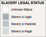
The legality of slavery polygons use as their base the 1860 county boundary files made publicly available by the National Historical GIS project at the University of Minnesota. We encoded each county or territory as a space in which slavery was recognized as legal, a space in which the rights of some slaveholders were significantly compromised, or a space in which slavery was forbidden by U.S. law.
The legality of slavery was contested in much of the United States before and during the Civil War. Our map reflects the both certainty with which laws were crafted, the inconsistency with which they were interpreted by the courts, and the unevenness with which these laws were put into practice. We have interpreted the Dred Scott decision as indicating that slavery was legal throughout the territories until June 1862, when a congressional act outlawed human bondage in U.S.-organized lands.
During the Civil War Congress acted at key moments to constrain the property rights of those supporting the Confederacy. Beginning with the Confiscation Act of 1861, any slaveholder who forced those he held in bondage "to work or be employed" in support of the Confederate military effort lost the right to own them. Congress increasingly tightened these restrictions on slavery, passing An Act Prohibiting the Return of Slaves in March 1862 and a second Confiscation Act in July 1862, freeing slaves of Confederate officials and anyone else supporting the Confederacy. These laws radically changed the rights of slaveholders supporting the Confederacy. Beginning in August 1861 we change the map of the legality of slavery to reflect the fact that wherever slavery existed legally in the U.S., it was significantly impaired by these laws.
The Emancipation Proclamation, on January 1, 1863, ended the right to hold slaves in places still held by the Confederacy. This announcement did little, in practical terms, that the Second Confiscation Act had not already done. Yet the proclamation took an entirely novel geographic perspective on the institution of slavery. Whereas earlier acts of Congress declared slaves free based on the actions of individual slaveholders, the Emancipation Proclamation declared ended slavery in entire districts based upon the war powers of the executive. Accordingly, we have designated the states "and portions thereof" included in the Emancipation Proclamation among those places where the federal government did not recognize slavery beginning in January 1863.
This proclamation excluded much of the American South. It particularly excluded any state that did not secede, leaving slavery untouched in Missouri, Kentucky, Maryland, West Virginia and Delaware. Slavery ended in many of these places by state law in 1864 and 1865, though slavery became illegal in Kentucky and Delaware only with the passage of the Thirteenth Amendment in late 1865. Indian nations living present-day Oklahoma signed treaties with the U.S. abolishing slavery the following year.
Union Army Regiments
Visualizing Emancipation for the first time plots the locations of regiments in the United States army. These locations should be regarded as approximations subject to a number of caveats.
Our information on the location of U.S. regiments comes from the careful cataloging of Frederick H. Dyer, a former drummer boy in the United States Army who went on to compile the Compendium of the War of the Rebellion (1908). The Compendium supplies a nearly complete list of Union regiments during the Civil War along with detailed descriptions of those units' movements over the course of the war. The Perseus Digital Library at Tufts University digitized this text, creating approximately 3500 files, one for each regiment, encoded according to the standards established by the Text Encoding Iniitative (TEI). Scholars at Perseus used algorithms to recognize the places and dates mentioned in Dyer's text.
Scholars at the Digital Scholarship Lab transformed these files into a format that mapping applications, such as Google Earth, can read. We paired the places and dates that Perseus identified in the Compendium, then went about checking for errors.
We are aware that errors, unfortunately, remain in this dataset. These arise from a few different sources. Frederick Dyer's Compendium is quite reliable, yet even more detailed and thoroughly researched sources exist for tracking U.S. Civil War military units, particularly the Supplement to the Official Records of the War of the Rebellion. Some errors were introduced into Dyer's text through digitization, and more errors appeared during the process of identifying placenames; some historical places are not listed in even the best modern gazeteers, while other places remained ambiguous to the computational models because they are shared by multiple locations. For more information on the digitization and data extraction process, see ***. The Digital Scholarship Lab introduced further errors in computationally pairing dates and locations. While we have caught hundreds of errors, we know that many others still remain to be corrected. We are currently looking for ways to correct remaining errors in the armies dataset.
Emancipation Events
The end of slavery in the United States was a complex process that occurred simultaneously in courtrooms and plantations, on battlefields and city streets. It involved a wide variety of human interactions, many of which we represent in this map as emancipation events. We have identified ten distinct but interrelated kinds of events, which are described in more detail here:
- Non-uniformed African Americans helping U.S. troops
- the abuse of African Americans
- the conscription of enslaved men and women by Confederates
- the conscription of African Americans by the Union for labor or armed service
- African Americans running away as fugitives
- Orders or regulations
- African Americans captured by U.S. military forces
- African Americans captured or re-enslaved by Confederates
- African American involvement in irregular fighting
- Protecting slave property from Union troops
These event types together capture most of the events we gathered in Visualizing Emancipation. Because these types of events are interrelated, many events are encoded with multiple types.
Undergraduate researchers at the University of Richmond recorded and coded events from a number of different sources. They searched through letters, diaries, and newspapers-particularly newspapers gathered in the Valley of the Shadow project and in the Richmond Daily Dispatch. They spent by far the most time on a full canvas of the Official Records of the War of the Rebellion. In most cases, we depended on the Making of America project at Cornell University for access to these texts, though in some cases we supplemented this version with the version digitized and managed by e-history at Ohio State University.
Students searched through this corpus for words commonly used during the Civil War to refer to African American men and women in the South: contraband, negro, black, colored, slave. If the document detailed the changing practice of slavery or its dissolution, students recorded it along with a number of pieces of information about that event, particularly its date, location, and an event type.
We were not always certain where an event occurred. Some events we were sure occurred on a certain city block; we had only the vaguest sense of where others happened. Because of this uncertainty, students recorded a precision level for each event. We represent this level of uncertainty as a halo around the events: if the map displays events at a zoom level that implies greater certainty than is warranted, the event is displayed with a halo that grows larger with our uncertainty about that event.
Undergraduate students also recorded the number of African Americans affected by events. Some events describe the actions of only one or two enslaved men or women; others describe the activities of thousands. More often, the sources give only the vaguest suggestion of the numbers of men and women involved: there were "several," "many," "masses." Because these descriptions are so unreliable, we do not currently represent on the map the number of men or women involved in an event. Each documented event is represented with a dot of the same size and color.
As of February 2012, student researchers have gathered 3400 emancipation events.
Event Types
Emancipation was a many-layered process that included the destruction of slavery in law, through military actions, and through the impetus of enslaved people throughout the U.S. South. Visualizing Emancipation brings together documentary evidence about emancipation into different themes or event types. These can be viewed alone or in any combination using our map interface. Some event types, such as “Fugitive slaves,” seem very much like they fit into a project on emancipation. We also include some types of events, such as the conscription of African Americans by Confederate troops, that seem at first glance to have little to do with the end of slavery, and more like they would lead to its perpetuation. Slavery ended through a winding process that at many times, places, and for many enslaved individuals seemed to lead anywhere but to freedom.
1. African Americans helping the Union
Over the course of the Civil War, African Americans helped Union troops in a variety of ways. This event type tags those places where former slaves aided troops in informal capacities, usually outside their conscription as laborers on plantations, as soldiers, or as cooks in military camps. We have especially used this tag to note where people of color gave information to U.S. forces or served as guides for troops navigating the southern terrain. They did so throughout the South, unevenly over the course of the war. Isaac I. Stevens found enslaved men of great help during his navigation of the Sea Islands. Near Coosaw Island he found Cyas, who, he wrote, "subsequently proved of great service from the intimate knowledge he possessed of the country." (OR I.6.i, 91-92)
2. Abuse of African Americans
Emancipation caused chaos on the land, and African Americans bore the brunt of this disruption. This category indicates places where whites in either the Union or the Confederacy abused people of color during the war. Documents tagged under this event include incidents of murder, discriminatory pay, beatings, and starvation. Perhaps the most infamous of these were the events at Fort Pillow. Brig. Gen. M. Brayman wrote to his superiors, describing the events there: "Fort Pillow was taken by storm at 3p.m. on the 12th, with six guns. The negroes, about 300, murdered, after surrendering with their officers. Of the 200 white men, 57 have just arrived, and sent to Mound City; about 100 are prisoners, and the rest killed. The whole affair was a scene of murder." (OR I.32.ii, 361)
3. Orders or regulations
Emancipation came about not only through the initiative of enslaved people or the actions of individual soldiers, but through official orders, policies, and regulations. Events tagged within this category were policy changes directly affecting the slave regime issued the Union and Confederate governments. Among other events, these include orders declaring enslaved men and women in a territory free, orders requiring commanders to send enslaved men and women to the quartermaster, and Confederate responses to emancipation and the enlistment of black troops. In Louisiana, for example, Confederate authorities struggled with the best approach to captured African American troops. While they saw the benefits of taking a hard line against black troops by enslaving them, they worried that such a policy could backfire. The Assistant Adjutant General in Confederate Louisiana in 1864, Charles Le D. Elgee, proposed treating US Colored Troop soldiers "with all proper leniency," as prisoners of war in order not to dissuade dissatisfied black troops from deserting the enemy. (OR I.34.ii, 953-54)
4. Conscription and Recruitment, Union
These events detail the marshaling of enslaved men and women in the fight against the Confederacy. Included in this category are the drafting of contraband men and women to work in military camps, fortifications, as soldiers, or as servants in various capacities. In some places, this was a systematic effort to draw upon black labor to the greatest possible degree. By July 1863, Gen. Nathaniel Banks reported from Louisiana that "every negro within the present lines of this department, or within reach of them, without distinction of age, sex, or condition, is in the service of the Government, either in the army or in producing food for the army and its dependents." (OR I.26.i, 573)
5. Conscription, Confederate
The Confederacy depended upon slave labor on plantations to provide food and the normal operations of its slave society, and near the front lines in direct service to the government. These events describe the ways that Confederates were able to use African American labor for their war effort. It includes orders and reports of impressment of slaves for use in building fortifications, railroads, and other efforts while bypassing most mentions of African Americans working as on privately held farms. Confederate conscription began early in the war. In late July, 1861, Gen. John B. Magruder ordered that half the male slaves and all free men of color in Gloucester, Middlesex, and Matthews Counties muster "to finish the works around Gloucester Point. Magruder promised recompense to the slaveowners: "fifty cents a day and a ration for each negro man during the time he is at work." (OR I.2.i, 1007) Magruder sent agents into the county to enforce the order.
6. Irregular fighting
This event category documents African Americans’ involvement in irregular fighting and appropriation of property that accompanied the Civil War, either as willing participants or as victims. Within this category we have collected incidents involving African Americans taking or destroying property claimed by landowners, enslaved men and women killing white civilians or military personnel, and instances where people of color were the objects of irregular fighting or pillaging.
Included among these events are the regrets of Maj. Gen. Samuel R. Curtis in a letter to Colonel N. P. Chipman in Helena, Arkansas the day after the emancipation proclamation went into effect. "I am sorry indeed," Curtis wrote, "to hear of the loss of Mrs. Craig's house by burning." Curtis wrote of their wealthy mutual acquaintance in a mournful tone: "Alas, this is war; although it was the negroes who did it, still, it is the result of war." (Samuel R. Curtis to N. P. Chipman, St. Louis, MO, January 2, 1863, OR I.22, 10-11)
7. Capture/enslavement/re-enslavement of African Americans by Confederates
Confederate troops and civilians made concerted efforts to re-enslave African Americans who had escaped their control during the war and to enslave free blacks who lived in northern states. This effort included counterattacks and ambushes on smaller Union regiments travelling with people of color, raids on contraband camps along the Mississippi and Atlantic seaboard, and dragnets at the edges of Confederate-held territory watching for the escape of African Americans from the southern interior.
During Confederate General Sterling Price's series of attacks in Missouri in the autumn of 1864, for example, a Confederate scouting party ran into a train of wagons manned by a small number of federal troops. Brig. Gen. John Shelby reported the results. They "captured 25, 2 caissons, 20 artillery horses with harness, 100 negroes, and 30 prisoners, besides killing and wounding a large portion of the guard." (OR I.41.iii, 978) Confederate attacks on African Americans such as this one appear throughout the U.S. South.
8. Fugitive slaves/runaways
Men and women ran from slavery to Union lines before any major battles had been fought. Events tagged as "Fugitive Slaves/Runaways" are instances where enslaved people ran away from their owners or turned up before Union units seeking protection. Many of these events are taken from newspaper advertisements seeking the return of escaped slaves. Typical is John Werth's complaint to the Richmond Daily Dispatch, promising a fifty dollar reward "for the apprehension and delivery to me, in Richmond, of Jack Oseen, a slave, who absconded last week from the fortifications in Chesterfield county. Jack is a black negro, about 19 years of age, slightly built, good teeth, but rather far apart, has a scar on the right hand, and another on the left wrist; was lately purchased from near Goldsborough, N.C." ("Fifty Dollars Reward," Richmond Daily Dispatch, April 1, 1863)
9. Capture of African Americans by Union troops
If many African Americans eluded slavery by leaving their plantations without outside intervention, others escaped through the direct intervention of United States troops. In many of these cases, military reports leave some ambiguity to the question whether enslaved men and women had any choice about leaving their property, neighbors, and homes. We have assigned instances of direct military intervention on plantations to this category, "Capture of African Americans by Union Troops." Brig. Gen. Grenville M. Dodge reported the results of his unit's expedition in northern Alabama in just this way: "It has rendered desolate one of the best granaries of the South, preventing them from raising another crop this year, and taking away from them some 1,500 negroes." (OR I.23.i, 249)
10. Protecting slave property from Union troops
Slave owners in the border South and Confederate states sought to protect their property in human beings from emancipation in any way they could. For slaveholders in the border South, this often meant pressing soldiers to return the men and women they claimed. In the Confederate states, especially after the Emancipation Proclamation, slave owners transported men, women, and children to places they hoped would be "safe" from Union troops and freedom. Events of this type document the efforts of slave owners to retain their property. Before his assault on Atlanta, Gen. William T. Sherman complained that he was encountering very few African Americans in northern Georgia, "because their owners have driven them" to the southwest corner of the state. "Negroes are as scarce in North Georgia as in Ohio. All are at and below Macon and Columbus, Ga." (OR I.39.ii, 132)
Scott Nesbit
Animations
Video 1
About the video
Video 2
About the video
Video 3
About the video
Video 4
About the video
Video 5
About the video
Video 6
About the video
Video 7
About the video
Video 8
About the video
Credits
Visualizing Emancipation is directed by Scott Nesbit, assistant professor of the digital humanities at the University of Georgia, and Edward L. Ayers, president emeritus, University of Richmond.
The project has benefitted from a large number of contributors at the University of Richmond and beyond. The Office of Digital Humanities at the National Endowment for the Humanities contributed to the project through a Digital Start-Up grant awarded through the We the People program. The University of Richmond contributed significant staff time to the project. Any vews, findings, conclusions, or recommendations expressed in this website do not necessarily represent those of the National Endowment for the Humanities.
The staff at the Digital Scholarship Lab has been intimately involved in nearly every aspect of the project. DSL director Robert K. Nelson contributed in countless ways to the conceptualization and implementation of the project. Nathaniel Ayers served as the project’s creative lead.
Staff members in the University of Richmond's Information Services and at Boatwright Library have been of great help. Rick Neal, with the cooperation of Bob Littlepage and the University of Richmond systems group, has provided expertise in server administration in our implementation of the project. Chris Kemp has provided help in working with xml-encoded texts and their transformations, and played a significant role in transforming the Union army information from textual description to mapped data.
A number of individuals have given valuable contributions to the project along the way. Gary Gallagher has served as an advisor to the project, Leslie Rowland and Robert Kenzer have given helpful feedback at key stages of the project’s development, and Kimberly Klinker has consulted with the project staff on metadata.
Student interns at the Digital Scholarship Lab collected nearly all the emancipation event data in Visualizing Emancipation. Over the last two years, Betel Akilu, Lauren Gallagher, Rachel Hall, Anthony Joga, Kathleen Lietzao, Perry Lowder, Holly McAleese, Amani Morrison, Vaquinda Motley, Dhruv Raturi, Franchesca Santos, Stefan St. John, Colleen Tobin and Darleen Underwood served as researchers for the project, learning more about the American Civil War than they had thought likely before entering college. Alexandra Bloomfield and Megan Molnar spent a great deal of time formatting and editing events from an early stage in the project and worked with the project directors to define Visualizing Emancipation’s event types. Alex Wan helped clean U.S. army data that had been generated algorithmically. These students were joined by volunteers from outside the University of Richmond, including Lindsey Edmonds, Tyler Garrett, and Kelly Douma. In addition to crediting those who helped the project before its launch, we would like to thank the volunteer contributors who are regularly submitting events from across the United States.
Azavea, a Philadelphia-based company specializing in the creation of geographic web software worked closely with the project directors to develop the mapping application. The application uses non-proprietary applications and technologies, including GeoServer, OpenLayers, and javascript to display information in a data-rich, interactive environment. The map employs ESRI’s light gray canvas basemap.
Visualizing Emancipation makes heavy use of a number of sources. Its emancipation events rely especially on the Official Records of the War of the Rebellion (Washington, DC: Government Printing Office, 1880-1901), made available by Cornell University Library’s Making of America project and Ohio State University’s ehistory site. U.S. regimental positions are gathered from Frederick Dyer, A Compendium of the War of the Rebellion (Des Moines: Dyer Publishing Company, 1908), digitized by Tufts University’s Perseus Digital Library. Emancipation events are also drawn from the University of Richmond’s Richmond Daily Dispatch collection and the University of Virginia’s Valley of the Shadow. The locations of Civil War-era railroads are made available at the geodata portal, courtesy of Harvard University’s Center for Geographic Analysis and based on John Bartholomew, "The Confederate states, with the border states & the adjoining portion of the Federal states" (London: George Philip & Son, [1864?]). All researchers on the end of slavery owe a debt of gratitude to Ira Berlin and the editors of the series Freedom: A Documentary History of Emancipation.